Effect of a change in sea level on worldwide topography
|
|
|
||||||||
|
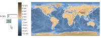
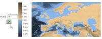
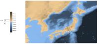
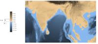
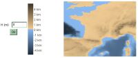
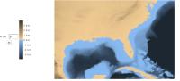
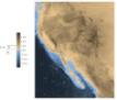
These java applets calculate the effect of a change in sea level on the topography for different regions of the world, such as Europe, Japan, the United States, South-East Asia or France. Input a value for the change of sea level (negative values for a decrease in sea level, positive value for an increase) in the left entry, the program recalculates the map of the region of interrest and adjusts the color scale. For information
As demonstrated by these (basic) calculations, the influence of such changes on the coastal contours is quite drastic. It was pointed out that some of the results might look surprising. For instance, if you get the map of France and a sea level of +4000m, you'll end up with the Mont Blanc under water... Well, this is simply a smoothing effect. These applets are based on samples extracted from the etopo5 topography dataset and do not include a full coverage. Therefore, a single spot like the top of the Mont Blanc is not treated properly. Similarly, colors are based on altitude only, so a place like Death Valley in the US might look underwater with the current sea level... If you want to download these applets to use them on your own web page or locally, please follow this link. There is also a downloable program that performs the same calculations and allows you to print or export the simulated maps into jpeg or png. It is available here: http://merkel.ZoneO.net/Topo/Programme/(sorry, available version is french only for now and includes topography files for the World, Europe and France) There is now another version of this software based on the google maps interface, you can find here: http://flood.firetree.net/. That project is completely independent from mine and I found it rather well done.
Sebastien Merkel, 07/2003
Last updated: 01/2007 |
|
|||||||||